The Kurds are moving so fast that the venerable Wikipedia article map on the ISIS war hasn't caught up yet. Enjoy your well-deserved vacation, user/editor Eratosthenian.
After taking Tall Abyad, the Kurds pushed south to secure Ain Issa and the nearby Brigade 93 army base. First, I'll draw it on the Wikipedia map I've been using for some time to give general context.

Looks like a march to al-Raqqah! Don't get too excited: the Kurds have no intentions of assaulting the city. But there's still very good news afoot: the Kurds are setting up their final choking of ISIS, which will assist the war efforts in both Iraq and Syria even if the Kurds sit around doing a whole lot of not-much once they regain Kurdish territory.
Let's look at a map with some roads for context--I doodled on Google Maps to get the idea across. The lines aren't that accurate mile-by-mile, but bear with me.

In the lower-right of the map we see al-Raqqah. Route 6 goes north to Tall Abyad, which is the closest crossing out of ISIS territory, to Turkey. We know that for some time, people, goods, and arms were flowing out of Turkey into Syria from the border crossing there. Now they're not. Already ISIS-held territory is seeing a spike in the price of food and other basic goods (according to the Syrian Observatory on Human Rights), which means shortages could loom if they're not able to establish another supply line elsewhere: the Euphrates has limited agricultural capacity and most domestic food comes from the West, which is not under ISIS control (and Syria is a net importer of many staple goods, like wheat). ISIS may be facing food shortages in the future, which could cripple the regime far faster than airstrikes.
Why is Ain Issa (the red-black marker on the map north of al-Raqqah) significant? Ultimately, it blocks ISIS from having access to the M4, which means the Kurdish rear is secure for an assault on Manbij. To get West from al-Raqqah, ISIS must travel along route 4 to the south of the Euphrates. Expect the Kurds to be regrouping quickly from the Tall Abyad assault, consolidating Samin, and then racing across the Euphrates via the M4 to take Manbij and Al Bab, both of which are heavily-settled Kurdish areas. Given recent Kurdish success so close to al-Raqqah and their new-found positioning advantage from taking Ain Issa, I expect the Kurds' chances are good.
The Kurds' final push in Syria will be to link up with their forces in the northwest and establish a secure front just north of Aleppo and across the Turkish border. Once they do this, they'll control all border crossings to Turkey, cutting ISIS off completely from foreign trade or smuggling. Securing al-Hasakah will also cut ISIS off from a concentrated area of arable land.
(I've included USDA agricultural maps of Syria and Iraq below to emphasize that ISIS' holdings are largely a bunch of non-arable desert).

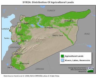
ISIS has been funded primarily through plunder and extortion, rather than production: without places to trade, their (admittedly vast) reserves of cash will become far less valuable. It will become very hard, very quickly, to get access to foreign fighters, weapons and ammunition, and food. The Kurds completing their conquests of northwestern Syria and the areas around al-Hasakah will complete a trade, recruitment, and agricultural choke-hold of ISIS, meaning time will no longer be on ISIS' side. And that's a really, really big deal.
After taking Tall Abyad, the Kurds pushed south to secure Ain Issa and the nearby Brigade 93 army base. First, I'll draw it on the Wikipedia map I've been using for some time to give general context.

Looks like a march to al-Raqqah! Don't get too excited: the Kurds have no intentions of assaulting the city. But there's still very good news afoot: the Kurds are setting up their final choking of ISIS, which will assist the war efforts in both Iraq and Syria even if the Kurds sit around doing a whole lot of not-much once they regain Kurdish territory.
Let's look at a map with some roads for context--I doodled on Google Maps to get the idea across. The lines aren't that accurate mile-by-mile, but bear with me.

In the lower-right of the map we see al-Raqqah. Route 6 goes north to Tall Abyad, which is the closest crossing out of ISIS territory, to Turkey. We know that for some time, people, goods, and arms were flowing out of Turkey into Syria from the border crossing there. Now they're not. Already ISIS-held territory is seeing a spike in the price of food and other basic goods (according to the Syrian Observatory on Human Rights), which means shortages could loom if they're not able to establish another supply line elsewhere: the Euphrates has limited agricultural capacity and most domestic food comes from the West, which is not under ISIS control (and Syria is a net importer of many staple goods, like wheat). ISIS may be facing food shortages in the future, which could cripple the regime far faster than airstrikes.
Why is Ain Issa (the red-black marker on the map north of al-Raqqah) significant? Ultimately, it blocks ISIS from having access to the M4, which means the Kurdish rear is secure for an assault on Manbij. To get West from al-Raqqah, ISIS must travel along route 4 to the south of the Euphrates. Expect the Kurds to be regrouping quickly from the Tall Abyad assault, consolidating Samin, and then racing across the Euphrates via the M4 to take Manbij and Al Bab, both of which are heavily-settled Kurdish areas. Given recent Kurdish success so close to al-Raqqah and their new-found positioning advantage from taking Ain Issa, I expect the Kurds' chances are good.
The Kurds' final push in Syria will be to link up with their forces in the northwest and establish a secure front just north of Aleppo and across the Turkish border. Once they do this, they'll control all border crossings to Turkey, cutting ISIS off completely from foreign trade or smuggling. Securing al-Hasakah will also cut ISIS off from a concentrated area of arable land.
(I've included USDA agricultural maps of Syria and Iraq below to emphasize that ISIS' holdings are largely a bunch of non-arable desert).

ISIS has been funded primarily through plunder and extortion, rather than production: without places to trade, their (admittedly vast) reserves of cash will become far less valuable. It will become very hard, very quickly, to get access to foreign fighters, weapons and ammunition, and food. The Kurds completing their conquests of northwestern Syria and the areas around al-Hasakah will complete a trade, recruitment, and agricultural choke-hold of ISIS, meaning time will no longer be on ISIS' side. And that's a really, really big deal.
No comments:
Post a Comment